
Terrain is the spatial base; mission sites are observed locations; resource and climate surfaces are analytical context. The interface avoids treating all geometry as if it had the same evidentiary status.
PLANETARY CARTOGRAPHY
Interactive Map of Mars
The map organizes Mars as a layered geographic system. Users can move from global relief to an individual site while retaining source, coordinate, uncertainty and model-version context.
Selecting the planet resolves geographic position and requests a local environmental profile from the Rust API. The response identifies which fields are observations, models or archived releases.
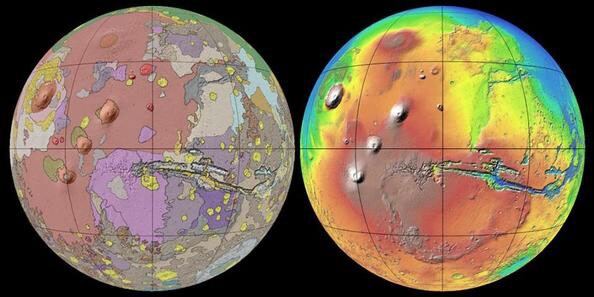
Colour expresses the active scientific layer, not a photographic view. Legends, units and provenance should be read together before comparing two regions.
Scientific dossier
Mars as a layered geographic system
Planetary cartography connects terrain, geologic interpretation, atmosphere, missions and analytical models without erasing their different origins. The map supports comparison rather than turning every coloured surface into an observed fact.
Four centuries of Mars maps
Telescopic observers drew changing markings. Spacecraft replaced speculative canals with craters, volcanoes, valleys and deposits. Modern mapping combines global mosaics with targeted observations at very different scales.
A geologically diverse planet
Mars preserves ancient highlands, younger volcanic plains, impact basins, canyon systems, polar deposits and landforms made by wind, ice and former flowing water.
From legend to source record
Relief colours encode elevation, geologic colours encode mapped units, atmospheric colours encode model variables, and symbols identify records. Defensible interpretation ends with product, mission, instrument, date, resolution and evidence class.
Primary reading and data sources
Explore the Mars knowledge system
MARS WEATHERMars Weather: Temperature, Pressure and Wind3D MARS GLOBEInteractive 3D Mars GlobeTHERMAL ENVIRONMENTTemperature on MarsMARS ATMOSPHEREAtmosphere and Pressure on MarsRADIATION ENVIRONMENTRadiation on MarsSOURCE REGISTRYMars Scientific Data SourcesREPRODUCIBLE METHODMars Operations Methodology