
The globe uses Mars Orbiter Laser Altimeter relief as its geographic frame. Elevation controls the shape of the planet and provides context for atmospheric pressure, access and settlement analysis.
3D MARS GLOBE
Interactive 3D Mars Globe
The 3D globe is a spatial reading interface, not a decorative planet. It combines a MOLA-derived surface with georeferenced sites and keeps observed, modelled and archival records visually distinct.
Mission locations and candidate sites remain attached to latitude and longitude while the globe rotates. Selection opens the corresponding evidence profile rather than moving a screen-space decoration.
The globe supports comparison of terrain, atmosphere, resources and infrastructure. Camera movement preserves planetary scale while site cards expose the assumptions behind each analytical layer.
Scientific dossier
From planetary measurements to a navigable globe
A scientific globe is a geodetic interface: every surface pixel, mission point and analytical layer must share a coordinate reference, declared resolution and source history.
History of global mapping
Mariner 9 surveyed almost the whole planet; Viking established global mosaics; Mars Global Surveyor measured topography with MOLA; MRO added high-resolution imaging and mineralogical context.
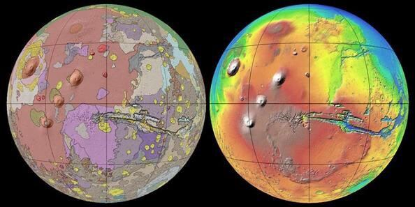
Geodesy, relief and geology
MOLA elevation creates a consistent frame for basins, volcanoes and sites. Rock age and composition still require mapped interpretation from imagery, spectroscopy, crater density and stratigraphic relationships.
Scale and responsible use
Screen resolution is not source resolution. Landing-scale conclusions require the underlying product, pixel size, acquisition geometry, uncertainty and mission constraints.
Primary reading and data sources
Explore the Mars knowledge system
MARS WEATHERMars Weather: Temperature, Pressure and WindPLANETARY CARTOGRAPHYInteractive Map of MarsTHERMAL ENVIRONMENTTemperature on MarsMARS ATMOSPHEREAtmosphere and Pressure on MarsRADIATION ENVIRONMENTRadiation on MarsSOURCE REGISTRYMars Scientific Data SourcesREPRODUCIBLE METHODMars Operations Methodology