
Source records enter a registry with authority, URL, time, unit, location and dataset version. They are classified before transformation so that a model result cannot silently become an observation.
REPRODUCIBLE METHOD
Mars Operations Methodology
The method normalizes heterogeneous public records without erasing provenance. Every calculated result is tied to a model version, input classes and an explicit interpretation limit.
Units and coordinates are normalized, then bounded functions calculate comparative indices for access, resources and environmental pressure. Scores support comparison; they are not physical measurements or mission approval.
Rust serves versioned JSON and server-rendered pages. Public cards expose evidence class and source links, while the methodology records assumptions, unavailable fields and update boundaries.
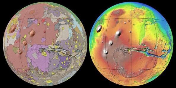
Scientific dossier
Transparent planetary modelling
The methodology separates observations, archives, cartographic products, climatological estimates and derived decision indices. Every public number should be traceable to a source class, transformation and model version.
Evidence classes
Observed, archived, cartographic, climatological and derived records answer different questions. Their separation prevents a model estimate from being presented as a live sensor reading.
MARS-SITE 1.0
MARS-SITE is a deterministic multi-criteria spatial assessment. It normalizes declared inputs, applies versioned weights and constraints, and reports viability separately from evidence confidence. It compares sites; it does not predict settlement success.
Validation, sensitivity and limits
Sensitivity analysis, benchmark sites, range checks and versioned tests reveal whether rankings are robust. Reproduction requires the data snapshot, formula version, parameters and source manifest; the model does not replace mission engineering or peer review.
Primary reading and data sources
Explore the Mars knowledge system
MARS WEATHERMars Weather: Temperature, Pressure and Wind3D MARS GLOBEInteractive 3D Mars GlobePLANETARY CARTOGRAPHYInteractive Map of MarsTHERMAL ENVIRONMENTTemperature on MarsMARS ATMOSPHEREAtmosphere and Pressure on MarsRADIATION ENVIRONMENTRadiation on MarsSOURCE REGISTRYMars Scientific Data Sources